

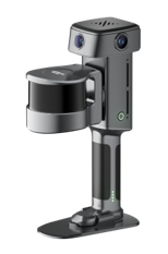
The XGRIDS Lixel L3 (32 Channel / 120m LiDAR Range) is the flagship high-accuracy spatial scanner. It holds a verified 5 mm relative accuracy and photorealistic colour across large, complex sites. A single pass produces a true-colour point cloud, a mesh, and a 3D Gaussian Splatting model — supporting precise measurement and true-to-life presentation alike. Deliverables fit directly into workflows across surveying and AEC, digital twin, and film and entertainment: the real world rebuilt in digital space.
The L3 fuses a high-accuracy LiDAR, a true-color vision system, an integrated RTK, and a built-in display into one unit: geometry, color, positioning, and delivery, in a single pass.
Specs:
LiDAR - 120m Maximum Range / 640,000 points per second
Onboard Display - 4.3” built-in touch screen, 1000 nit peak brightness / scan assist system
Integrated RTK - Built-in Survey Grade RTK module, multi frequency GNSS across GPS, GLONASS, Galileo and Beidou
High Precision IMU with 4k HDR imaging
The XGRIDS Lixel L3 (32 Channel / 120m LiDAR Range) is the flagship high-accuracy spatial scanner. It holds a verified 5 mm relative accuracy and photorealistic colour across large, complex sites. A single pass produces a true-colour point cloud, a mesh, and a 3D Gaussian Splatting model — supporting precise measurement and true-to-life presentation alike. Deliverables fit directly into workflows across surveying and AEC, digital twin, and film and entertainment: the real world rebuilt in digital space.
The L3 fuses a high-accuracy LiDAR, a true-color vision system, an integrated RTK, and a built-in display into one unit: geometry, color, positioning, and delivery, in a single pass.
Specs:
LiDAR - 120m Maximum Range / 640,000 points per second
Onboard Display - 4.3” built-in touch screen, 1000 nit peak brightness / scan assist system
Integrated RTK - Built-in Survey Grade RTK module, multi frequency GNSS across GPS, GLONASS, Galileo and Beidou
High Precision IMU with 4k HDR imaging